Our biological planning and decision support tools help wildlife agencies, conservation groups, and other partners design effective and efficient conservation programs and strategies that result in the greatest benefits to birds. These tools are based on the latest science and the best available avian and geospatial data, and they are subject to rigorous review and revision.
The Implementation Plan is our primary planning tool and guides the partnership’s conservation efforts.
The primary planning tool is the Joint Venture’s Habitat Conservation Implementation Plan, featured below, which provides habitat conservation goals that support our regional bird population objectives. It also includes strategies to help guide the PLJV partnership’s efforts to reach those goals.
We also provide the following information and tools to inform conservation planning:
- Bird data to inform, target, and evaluate habitat projects
- Playa research, using both biological and social science, to inform conservation
- Playa tools including interactive and downloadable maps, datasets, land use calculator, and recharge and wetness estimators
PLJV Habitat Conservation Implementation Plan
The Implementation Plan is a working document that will continue to be updated as we develop new conservation strategies and track our progress in achieving our conservation goals. You can view our Implementation Strategies Tables, one for each of the state bird conservation regions, for more details about our habitat objectives and see how your organization’s work can contribute to the partnership’s conservation goals. Each table describes the current condition of the landscape in that area and the projected changes due to agricultural conversion, shows our habitat goal and what is needed to reach the goal, and lists the current projects being implemented in each region with the number of associated acres conserved. We will also be adding a spatial component to guide the partnership’s conservation efforts in order to focus on areas that provide the greatest opportunities.
During the planning process, we started with the population goals from the four continental bird plans and stepped them down to our region, then developed habitat conservation goals for each state, by bird conservation region (BCR), to support our regional population goals. Next, we sought to understand two things, what our current landscape looks like and how it is predicted to change in the future. Finally, we developed conservation strategies that can begin to address the conservation challenges we face.
Our Framework Birds
The PLJV region is home to over 520 species of birds that use grasslands, wetlands, riparian areas, and other habitats during breeding and non-breeding seasons. To focus our conservation work, we narrowed this long list of breeding birds to those species for which our actions could have a measurable impact and set population objectives for these species with the intent to reverse population declines and restore breeding populations equal to 1970 estimates. These framework birds (see bird data tables) were determined using the following criteria:
- More than 8% of the global population of the species can be found within the shortgrass and mixed-grass bird conservation regions (BCR 18 and 19).
- The birds have a declining or unknown population trend in either BCR 18 or 19 according to the Breeding Bird Survey, or the species is a gamebird important to our state agencies.
Next, we used land cover information and our Hierarchical All Bird Systems (HABS) database, which relates densities of birds in each habitat type to the number of acres of that habitat type across multiple bird species and habitats simultaneously, to estimate the current carrying capacity of our landscape to support breeding landbirds. This estimate allows us to understand how conservation work can both benefit some species and reduce habitat for others.
Grassland Habitat Goals
For our grassland birds, we estimated the number of acres of short and mixed-grass prairie, sandsage, shinnery oak and land enrolled in the USDA Conservation Reserve Program. Then, we estimated how many additional acres will be necessary to meet our population objectives and the rate at which grasslands are being converted to cropland or encroached by woody species every year. The rate of grassland conversion was developed using data from a JV8 Great Plains Grassland Assessment funded by ConocoPhillips and the Rangelands Analysis Platform.
To recover grassland songbirds, our analysis shows we need multiple goals:
- Protect current grasslands. While approximately 1.2% of our landscape is already protected as public land or under conservation easements, our goal is to have 5% of our landscape protected in the next ten years.
- Restore more than 17 million acres of grass through conservation programs such as the USDA Conservation Reserve Program.
- Manage or remove woody plants on more than 11 million acres over the next decade.
Our next task is to determine where this conservation will be most important. We intend to identify strongholds of intact grassland and focus our energy on maintaining these grasslands, expanding them to make larger blocks of grassland, and connecting large blocks of grassland with corridors. Read more about our grassland goals >>
Playa Habitat Goals
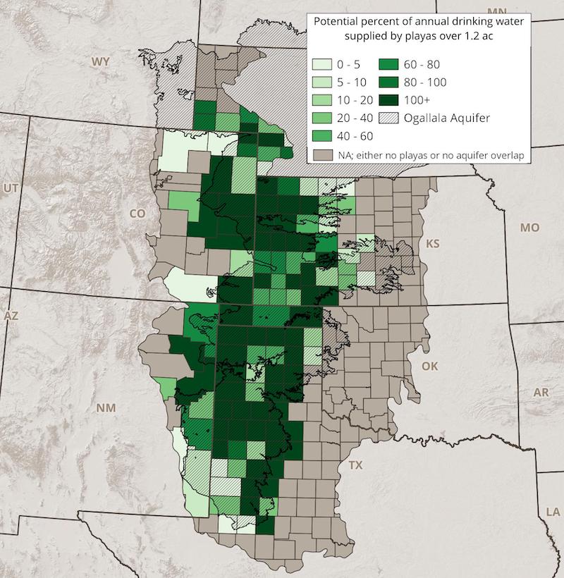
We used energetics models to estimate the number of playa acres needed to support our population objectives for migrating and wintering waterfowl and shorebirds. Across the region, as water supplies are declining, we’ve found the rate of playa conservation increases when we collaborate with landowners and communities to provide a sustainable water source with playa restoration as part of the solution. Therefore, our playa goal is stated as the number of playa acres needed to provide drinking water for the people in counties over the aquifer.
While the amount of potential recharge through playas varies for each county — based on number of playas over the aquifer, population, and other factors —we are challenging ourselves to restore enough playas to provide 50% of drinking water needs, when possible. If we achieve this goal, these playas will provide enough habitat to support approximately 20% of our waterfowl objectives and 8% of our shorebird objectives, as well as about 12% of our goal to recover grassland songbirds through the Conservation Reserve Program by establishing grass buffers around the playas. Read more about our playa goals >>
Wetland Habitat Goals
There are approximately 1,082,000 acres of large wetland complexes in the PLJV region, most of which are already protected and conserved as federal and state wildlife areas. Our goal is to continue to maintain these wetlands in conditions that provide suitable roosting and feeding habitat for migrating and wintering shorebirds and waterfowl. By doing so, we can meet and exceed habitat needs for these birds, which were determined using energetics models to estimate the acres of wetlands needed.
To see the number of wetland acres by state Bird Conservation Region (BCR), as well as more information on our other habitat goals, view our Implementation Strategies Tables. You can also read about how we are managing wetlands.
Riparian Habitat Goals
For our riparian birds, we estimated the number of acres of woodland, shrubland, and grassland along the rivers in our region, then how many acres of restoration are needed to meet our population objectives. To meet our objectives, we estimate approximately 1 million acres of riparian habitat need to be restored.
Waterfowl also use floodplain marsh and warm water sloughs, and shorebirds use sand bars and mud flats in and along the rivers. We are still working to determine the amount of these habitats currently on the landscape and how much restoration work is needed.
To see the number of estimated current and needed riparian acres by state Bird Conservation Region (BCR), as well as more information on our other habitat goals, view our Implementation Strategies Tables.
Our Planning Process
Let’s take a look at how we developed the Implementation Plan by looking at one habitat type — playas. First, we used energetics models to estimate the number of playa acres needed to support our population objectives. These energetics models estimate the amount of energy or calories needed to support migrating and wintering waterfowl and shorebirds.
After estimating how many playa acres are needed to support our birds, we sought to understand the current status of playas within our landscape and calculate the current number of healthy playa acres as well as the number of modified playa acres — playas that are farmed through or have a pit, for example.
This information helps us understand how many playas are currently able to support waterfowl and shorebirds (healthy playas), how many additional playas or playa acres need to be restored, and where the restoration work needs to happen to support our population goals. We also considered other factors that may affect habitat suitability. For instance, since playas with wind turbines near them are not suitable habitat for waterfowl and shorebirds, they are not included in the set of potential playas to restore to provide bird habitat; however, those playas may still be part of a local restoration plan to provide groundwater recharge to support a town or community.
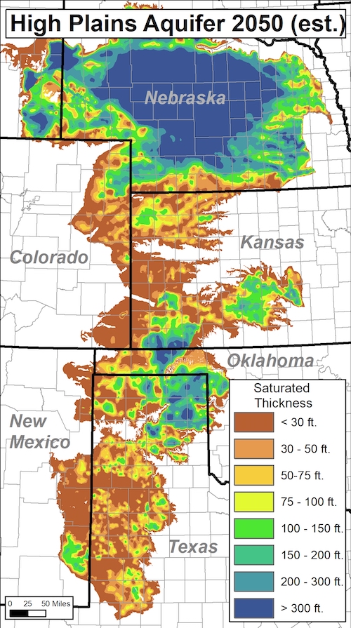
Playas are primary points of recharge to the Ogallala aquifer, so we also consider current and projected changes to the saturated thickness, particularly in areas that are rapidly declining (see aquifer map). By including that in our planning process, we can focus our playa conservation efforts in areas where restoration will benefit not only wetland birds but also the people who live and work on the landscape. Across the region, as water supplies are declining, we’ve found the rate of playa conservation increases when we collaborate with landowners and communities to provide a sustainable water source with playa restoration as part of the solution.
Once we considered all of the information described above, we decided to state our playa restoration goal as the number of playa acres needed to provide 50% of the drinking water needs for the people in counties over the aquifer. That goal is much more relevant to the producers and local communities who own the playas — and still provides the needed bird habitat. By achieving this goal, playas will provide enough habitat to support approximately 20% of our waterfowl objectives and 8% of our shorebird objectives, as well as about 12% of our goal to recover grassland songbirds through the Conservation Reserve Program by establishing grass buffers around the playas. So how much playa restoration is needed to meet our playa goal and support bird population objectives?
The table below shows the number of healthy playa acres currently in each state, the playa acres needed, and how many playa acres need to be restored each year for the next 10 years to meet our playa goals as described above. Because the playa landscape is continually changing, we have factored in the projected loss of healthy playas from sediment accumulation, which ranges from a low of 1.2% loss in New Mexico to a high of 2% loss in Nebraska, when determining our annual playa restoration goals.
Planning Area | Healthy Playas | Total Playa Restoration Needed | Annual Playa Restoration Needed |
Colorado | 7,116 acres | 7,769 acres | 1,377 acres |
Kansas | 9,636 acres | 25,343 acres | 5,534 acres |
Nebraska | 2,037 acres | 4,712 acres | 791 acres |
New Mexico | 11,126 acres | 16,159 acres | 2,006 acres |
Oklahoma | 2,968 acres | 2,954 acres | 845 acres |
Texas | 132,812 acres | 143,408 acres | 24,340 acres |
GET INVOLVED
If you’re conducting habitat work, we’d like to know about it and include it in our Implementation Plan tracking and success stories. Please contact PLJV Science Coordinator Anne Bartuszevige to tell us what you’re working on — no matter how big or small the project — and discuss collaboration opportunities.

