
To better understand grassland bird declines and implement habitat conservation strategies to address these declines, we collect information about the distribution and abundance of bird species across our region, as well as the habitat they use, through Bird Conservancy of the Rockies’ Integrated Monitoring in Bird Conservation Regions (IMBCR) program. This program provides much-needed, scientifically defensible estimates of bird distribution and abundance across large regions that can be used by conservation organizations, state and federal agencies, and other partners to target and evaluate habitat projects throughout the region.
Evaluation Studies
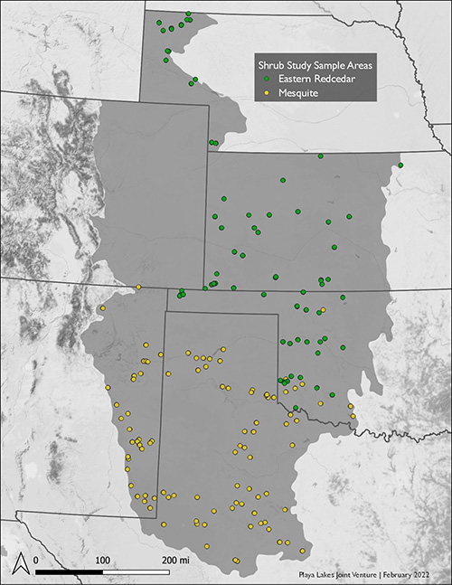
Sample areas. Data sources: PLJV and ESRI. Click to enlarge
The structure of the IMBCR sampling protocol also allows for studies that help answer specific questions, as well as the collection of baseline data. These studies help PLJV partners evaluate habitat conservation efforts and inform future strategies.
In 2019, the PLJV partnership launched its first evaluation study to learn more about how woody plant encroachment is affecting grassland birds. For two years, we temporarily reallocated a portion of our baseline grids to specifically collect data on bird presence across a gradient of woody plant encroachment. In 2019, we focused on the southern half (New Mexico, Oklahoma, and Texas) of our Joint Venture where the spread of mesquite is a concern. In 2020, we focused on the northern half (Kansas, Nebraska, and Oklahoma) where eastern redcedar is a concern. Our intent was to investigate the thresholds at which our most sensitive grassland birds stop using an area due to invasive woody plants and birds preferring shrubbier habitats begin to dominate the community.
Below are two examples of how partners are using this type of IMBCR data.
Texas Parks and Wildlife Department
Texas Parks and Wildlife Department (TPWD) biologists working at Matador Wildlife Management Area (WMA) have been implementing mechanical, chemical, and prescribed burning treatments to manage and remove mesquite from the property for nearly 20 years, with the intent of improving conditions for grassland wildlife. In 2019, PLJV began collaborating with them to evaluate the effectiveness of the different mesquite control practices on grassland birds using the IMBCR program. Since the WMA staff know which treatments were applied in each pasture, pairing that information with the IMBCR data on bird populations helps them know if their strategies are working — and exactly how effective they are.
The study found that densities of several grassland birds were higher on Matador with the invasive mesquite removed than in areas outside the WMA. The value of this and other IMBCR data isn’t limited to Matador WMA. Texas Parks and Wildlife will be using it to help guide management of invasive woody plants in other areas of Texas as well. In 2022, PLJV will continue evaluating the effectiveness of the mesquite treatments and expand the study to other WMAs. View Report >>
Bureau of Land Management
The Roswell and Carlsbad Bureau of Land Management (BLM) field offices have been trying to remove mesquite on their lands, as well as surrounding state and private lands, using herbicides. The intent is to improve habitat for Lesser Prairie-Chickens, a species that is well known for avoiding tall woody vegetation, but BLM staff also want to know how this restoration work benefits other species of grassland birds.
To answer that, we are using targeted IMBCR sampling to help measure grassland bird response to shortgrass prairie and shinnery-oak habitat restoration at select project sites on BLM land in eastern New Mexico. The objective of this study is to evaluate how mesquite removal influences the abundance of grassland birds. This study is on-going and will be completed in 2022.


Data for the PLJV Region
To create an accurate picture of bird populations, surveys are conducted everywhere birds are found across the PLJV landscape. Sample sites are randomly selected using a spatially balanced sampling design which allows for model inference across the entire landscape. A square kilometer grid is placed over the entire PLJV area and the area is subdivided into strata. Sample sites are randomly selected from within each stratum. IMBCR has a hierarchical design, so the data collected at smaller scales can be aggregated to make inferences about impacts at the larger scale. One reason this can be done is because data points are not tied to habitat types or conditions, which can change and interrupt the continuity of the data, but rather, are tied to physical features (e.g., rivers) or political boundaries (e.g., states). Within these strata, all vegetation types may be sampled.
We have developed a framework for identifying breeding birds for which we should target conservation actions. These framework birds must meet the following two criteria:
- More than 8% of the global population can be found within the shortgrass and mixed-grass bird conservation regions (BCR 18 and 19).
- The birds have a declining or unknown population trend in either BCR 18 or 19 according to the Breeding Bird Survey or the species is a gamebird important to our state agencies; unfortunately, all the gamebirds identified by state agencies also meet the first two criteria.
Bird Data for Rivers
PLJV has many birds that are of conservation concern that require woody vegetation often found along rivers in the region – birds such as Baltimore Oriole, Bullock’s Oriole, Bell’s Vireo, and Yellow-billed Cuckoo.
Sampling in habitats along rivers allows us to estimate bird densities which can be used as baseline data for understanding the effectiveness of conservation efforts in riparian areas. In these tables, you’ll see the estimated density of birds detected along rivers in the shortgrass and mixed-grass bird conservation regions (BCR 18 and 19) averaged from 2016 to 2020.
Please note, the estimates and standard deviations presented here are for illustrative purposes only. For density and occupancy estimates specific to your interests, visit the Rocky Mountain Avian Data Center where you can query the database (how to create a sample query).
Framework Species | Avg Density BCR 18 (2016-20) | Std Dev | High Confidence | Avg Density BCR 19 (2016-20) | Std Dev | High Confidence |
Baltimore Oriole | 0.06 | 0.03 | 8.33 | 2.86 | X | |
Bell's Vireo | 0.12 | 0.07 | 2.63 | 1.21 | X | |
Bewick's Wren | 2.58 | 1.94 | X | 7.38 | 3.34 | X |
Black-crowned Night Heron | 0.01 | 0.01 | N/A | N/A | ||
Brown Thrasher | 0.26 | 0.08 | X | 1.35 | 0.41 | X |
Bullock's Oriole | 4.93 | 0.53 | X | 1.90 | 1.41 | X |
Clark's Grebe | N/A | N/A | N/A | N/A | ||
Common Grackle | 12.91 | 1.01 | 6.92 | 4.58 | ||
Great Horned Owl | 0.10 | 0.06 | 0.26 | 0.16 | ||
King Rail | N/A | N/A | N/A | N/A | ||
Least Tern | N/A | N/A | N/A | N/A | ||
Mississippi Kite | 0.21 | 0.19 | 0.91 | 1.33 | ||
Orchard Oriole | 1.08 | 0.52 | X | 4.38 | 2.59 | X |
Painted Bunting | 1.50 | 0.71 | X | 20.86 | 6.35 | X |
Piping Plover | N/A | N/A | N/A | N/A | ||
Red-headed Woodpecker | 0.62 | 0.39 | X | 2.82 | 0.90 | X |
Snowy Plover | N/A | N/A | N/A | N/A | ||
Wild Turkey | 0.21 | 0.09 | 0.43 | 0.09 | ||
Yellow-billed Cuckoo | 0.29 | 0.23 | X | 1.95 | 1.10 | X |


Bird Data for Playas
Playas are the most numerous wetlands in the PLJV region; therefore, understanding how conservation efforts benefit wetland, and upland, birds is essential. Playas are embedded in grasslands and croplands and thus don’t have a specific suite of breeding birds associated with them. However, American Avocets can be found foraging in wet playas, and hunters have often reported that Ring-necked Pheasants can be found near dry playas where vegetation is thicker than the surrounding landscape.
Sampling in and near playas allows us to track changes in estimated bird densities which can be used as baseline data for understanding the effectiveness of our conservation efforts. In these tables, you’ll see the estimated density of birds detected in and near playas in the shortgrass and mixed-grass bird conservation regions (BCR 18 and 19) averaged from 2016 to 2020.
Please note, the estimates and standard deviations presented here are for illustrative purposes only. For density and occupancy estimates specific to your interests, visit the Rocky Mountain Avian Data Center where you can query the database (how to create a sample query).
Framework Species | Avg Density BCR 18 (2016-20) | Std Dev | High Confidence | Avg Density BCR 19 (2016-20) | Std Dev | High Confidence |
American Avocet | 1.29 | 0.98 | 0.41 | 0.47 | ||
Brown-headed Cowbird | 6.52 | 0.98 | 8.97 | 1.43 | ||
Burrowing Owl | 0.09 | 0.11 | 0.004 | 0.01 | ||
Cassin's Sparrow | 11.94 | 5.72 | X | 12.44 | 6.82 | X |
Chihuahuan Raven | 0.09 | 0.06 | 0.14 | 0.14 | ||
Common Nighthawk | 0.41 | 0.16 | X | 1.42 | 0.49 | X |
Eastern Kingbird | 0.002 | 0.004 | N/A | N/A | ||
Eastern Meadowlark | 1.75 | 1.41 | X | 4.22 | 1.28 | X |
Ferruginous Hawk | N/A | N/A | N/A | N/A | ||
Grasshopper Sparrow | 46.23 | 18.56 | X | 33.62 | 6.56 | X |
Greater Prairie-Chicken | N/A | N/A | N/A | N/A | ||
Horned Lark | 82.80 | 10.22 | 53.98 | 12.14 | ||
Killdeer | 4.09 | 0.85 | X | 4.97 | 2.18 | X |
Lark Bunting | 5.11 | 6.72 | 2.58 | 4.65 | ||
Lark Sparrow | 1.97 | 0.44 | X | 6.61 | 2.34 | X |
Lesser Prairie-Chicken | 0.28 | 0.34 | 0.24 | 0.38 | ||
Loggerhead Shrike | 0.11 | 0.14 | 0.07 | 0.16 | ||
Long-billed Curlew | 0.05 | 0.02 | X | N/A | N/A | |
Mountain Plover | N/A | N/A | N/A | N/A | ||
Mourning Dove | 6.92 | 1.69 | X | 9.78 | 2.51 | X |
Northern Bobwhite | 1.25 | 0.68 | X | 6.11 | 4.91 | X |
Red-winged Blackbird | 22.52 | 4.09 | 35.94 | 7.06 | ||
Ring-necked Pheasant | 1.60 | 0.35 | X | 1.41 | 0.35 | X |
Rufous-crowned Sparrow | 0.06 | 0.14 | N/A | N/A | ||
Scaled Quail | 0.98 | 1.12 | 0.11 | 0.15 | ||
Scissor-tailed Flycatcher | 0.88 | 0.45 | 7.49 | 2.27 | X | |
Swainson's Hawk | 0.20 | 0.06 | X | 0.12 | 0.05 | |
Thick-billed Longspur | N/A | N/A | N/A | N/A | ||
Upland Sandpiper | 0.02 | 0.02 | N/A | N/A | ||
Western Kingbird | 8.56 | 1.15 | X | 3.87 | 1.51 | X |
Western Meadowlark | 24.44 | 3.12 | X | 15.89 | 3.38 | X |


Bird Data for Other Habitats
IMBCR grids can be found on all types of habitats in the PLJV region. While most grids tend to fall on grassland or cropland, due to the composition of our landscape, grids are also sampled on CRP fields, grasslands with invasive woody plants, and even urban areas. As you might expect, a wide variety of birds are detected, but we pay close attention to declining grassland songbirds such as Cassin’s Sparrow, Lark Bunting, Grasshopper Sparrow, and Eastern and Western Meadowlarks.
Sampling in all areas of our region allows us to track changes in estimated bird densities which can be used as baseline data for understanding the effectiveness of our conservation efforts. In these tables, you’ll see the estimated density of birds detected in the shortgrass and mixed-grass bird conservation regions (BCR 18 and 19) averaged from 2016 to 2020.
Please note, the estimates and standard deviations presented here are for illustrative purposes only. For density and occupancy estimates specific to your interests, visit the Rocky Mountain Avian Data Center where you can query the database (how to create a sample query).
Framework Species | Avg Density BCR 18 (2016-20) | Std Dev | High Confidence | Avg Density BCR 19 (2016-20) | Std Dev | High Confidence |
American Avocet | 0.15 | 0.22 | N/A | N/A | ||
Brown-headed Cowbird | 4.86 | 1.11 | 29.92 | 6.11 | ||
Burrowing Owl | 0.11 | 0.11 | 0.03 | 0.07 | ||
Cassin's Sparrow | 27.47 | 3.51 | X | 4.71 | 2.14 | X |
Chihuahuan Raven | 0.20 | 0.05 | 0.11 | 0.08 | ||
Common Nighthawk | 0.68 | 0.26 | X | 1.91 | 0.93 | X |
Eastern Kingbird | 0.10 | 0.10 | 3.36 | 2.06 | X | |
Eastern Meadowlark | 5.78 | 1.36 | X | 10.11 | 3.84 | X |
Ferruginous Hawk | 0.05 | 0.06 | N/A | N/A | ||
Grasshopper Sparrow | 31.37 | 15.60 | X | 33.34 | 13.61 | X |
Greater Prairie-Chicken | N/A | N/A | 0.01 | 0.02 | ||
Horned Lark | 49.82 | 4.68 | 20.11 | 7.43 | ||
Killdeer | 1.53 | 0.44 | 2.79 | 0.80 | X | |
Lark Bunting | 4.02 | 3.36 | 0.20 | 0.35 | ||
Lark Sparrow | 8.75 | 3.38 | X | 8.02 | 1.71 | X |
Lesser Prairie-Chicken | 0.01 | 0.01 | 0.11 | 0.24 | ||
Loggerhead Shrike | 0.41 | 0.17 | X | 0.05 | 0.12 | |
Long-billed Curlew | 0.06 | 0.05 | N/A | N/A | ||
Mountain Plover | N/A | N/A | N/A | N/A | ||
Mourning Dove | 8.99 | 0.51 | X | 12.93 | 1.11 | X |
Northern Bobwhite | 2.56 | 0.50 | X | 8.10 | 3.57 | X |
Red-winged Blackbird | 12.19 | 4.23 | 15.09 | 4.36 | ||
Ring-necked Pheasant | 1.26 | 0.58 | X | 1.87 | 0.35 | X |
Rufous-crowned Sparrow | 1.84 | 1.75 | X | 0.37 | 0.39 | |
Scaled Quail | 4.08 | 1.55 | X | 0.06 | 0.12 | |
Scissor-tailed Flycatcher | 0.55 | 0.21 | 7.57 | 1.77 | X | |
Swainson's Hawk | 0.17 | 0.03 | X | 0.03 | 0.04 | |
Thick-billed Longspur | N/A | N/A | N/A | N/A | ||
Upland Sandpiper | 0.01 | 0.02 | 0.27 | 0.26 | X | |
Western Kingbird | 10.62 | 1.67 | X | 5.08 | 1.49 | X |
Western Meadowlark | 16.75 | 5.13 | X | 9.40 | 5.03 | X |


IMBCR for PLJV Program
We work with many partners, including our management board, to fund the Integrated Monitoring in Bird Conservation Regions (IMBCR) program across our six states and provide high-quality bird data. In this way, no one entity bears a high burden of the financial cost.
An advisory committee representing the partnership guides data modeling and management questions. It includes representatives from Colorado Parks and Wildlife, Kansas Department of Wildlife and Parks, Nebraska Game and Parks Commission, New Mexico Department of Game and Fish, Oklahoma Department of Wildlife Conservation, Texas Parks and Wildlife, and US Fish and Wildlife Service. Representatives on the advisory committee provide input on products that will be of use to their work and future management questions for investigation.
GET INVOLVED
For information about IMBCR for PLJV or how to participate, contact Conservation Science Director Anne Bartuszevige.